Lookout
The Lookout flying site, located on Mt. Zion in Golden, CO has restricted landing fields, it is in the public eye, and is the only remaining flying site on the Front Range that offers convenient drive-up access to launches. All pilots must receive a site intro before flying Lookout.
Pilots rated less than P4 or H4 are required to participate in the Lookout Sponsorship Program.
The site is at approximately 6800 ft MSL, 1000ft above the primary LZ. Launches include possible NE, E. Launches face E and the best flying is had with NE through E wind. It's primarily a thermal site with little ridge soaring opportunity. Mornings are mostly calm, suitable for sponsoring new pilots. Midday finds strong thermal activity with frequent thunderstorms from May-August. Evenings occasionally glass off. Flying is possible year round. Lookout has good XC potential; the Colorado state hang gliding record was set here - 187 miles by Brad Koji, and paragliding record of 181 miles by Jan Voegeli.
Lookout Landing Zone "LZ" is owned by the Colorado School of Mines and by the City of Golden. We fly with permission of these organizations and are required to restrict flying at Lookout to qualified pilots. With that said, we’ll do everything we can to help qualified pilots enjoy this great flying site as much as we do!
Lookout Requirements
All Pilots Must Receive a Site Briefing from a Sponsor/Observer
- PG
- P3 Rated 10 Sponsored Flights (exception for local P2 Pilots)
- HG
- H3 Rated 10 Sponsored Flights
- MW
- S2 or P2/M1 Rated 5 Sponsored Flights
Memberships
- Must be a member of USHPA
- Must be a member of RMHPA (Join/Renew)
Visiting pilots (less than 5 visits) may waive the fee but must complete the membership form and Jefferson County Waiver (if flying Lookout). - 2023 Jeffco Waiver
Once you meet the requirements get started with the
Lookout Sponsorship Program.
Communications
Radio Frequency
158.400 MHz DCS 23 -- DCS Guide
Telegram Groups
New to the area? Post a quick message about yourself so we know your'e not a spammer will get you access to the private Telegram groups.
RMHPA Telegram Groups
Introduction Video for Paraglider Pilots:
Introduction Video for Hang Glider Pilots:
Safety
Nothing good ever happens on a strong south day.
- Avoid flying close to the terrain. Lookout has much more turbulence near terrain as compared to other sites and has a history of terrain induced incidents that can be avoided if this advice is respected.
- When you are below the second road crossing, you should head out to the LZ rather than scratching low looking for lift.
- Avoid flying deep behind the hill. You can be pinned in the wind and blown over the back.
- Monitor windsocks to understand changing wind conditions.
- Avoid getting low in the South Bowl. It produces strong turbulence and is deadly in N conditions.
- Avoid getting pinned in the wind low over Windy Gap.
- Avoid flying in the venturi of Clear Creek Canyon. You can be pinned in the wind.
- A Hang Glider wing generally obstructs the pilot's view of the sky above. Respect this when flying above Hang Gliders.
- Hang Gliders can dive fast. If a paraglider thinks they may have a landing conflict with a hang glider, the paraglider should try to stay up, let the hang glider dive to land first.
| Ideal Wind Range | Max Winds |
|---|---|
| HG 3 - 12 mph | 25 mph |
| PG 3 - 10 mph | 15 mph |
| MW/SW 3 - 15 mph | 18 mph |
Each pilot needs to individually determine his/her ideal flying conditions.
Launches
North Launch
The most commonly used launch. This launch faces NE and favors NE through E wind. CAUTION: Flight is possible with a N crosswind but this condition may produce terrain induced turbulence just after takeoff. CAUTION: Flight is possible in light SE wind but is generally discouraged due to terrain induced turbulence from the spine just S of launch. Additionally, it is widely agreed that soaring and landing conditions are poor with wind SE wind. CAUTION: Do not fly Lookout in strong SE wind or anytime the wind is S or W. These represent critically dangerous flying situations. Get a site briefing or ask a local for weather advice.
North launch has several wind socks to help monitor variable conditions.
Avoid flying deep in Clear Creek canyon to the north. Avoid thermalling deep behind the hill above launch.
Paragliders typically setup and launch slightly higher up the hill. Hang gliders setup and often launch from a position lower down. There are tie downs for hang gliders in the staging area.
Experienced pilots tend to prefer the North launch as it is easier to determine a South wind component. Avoid flying in strong south conditions.
South Launch
This is a gently sloping grassy field at the top of a wide bowl. This launch favors NE through E wind. This launch can be used in light SE wind but this wind direction typically results in poor soaring and landing conditions at Lookout. CAUTION: do not use this launch with N wind. The spine to the N produces deadly turbulence. CAUTION: Do not fly Lookout in strong SE wind or anytime the wind is S or W. These represent critically dangerous flying situations. Get a site briefing or ask a local for weather advice.
Windy gap lies just to the south, and can have strong venturi. Avoid this area. The Miner's field landing zone is visible just to the south.
Several Tandem operations use the south launch extensively. There is plenty of room to give Tandem pilots the space they need to work safely. Individual pilots have many options to lay out and launch without affecting Tandem pilots.
Landing Zones
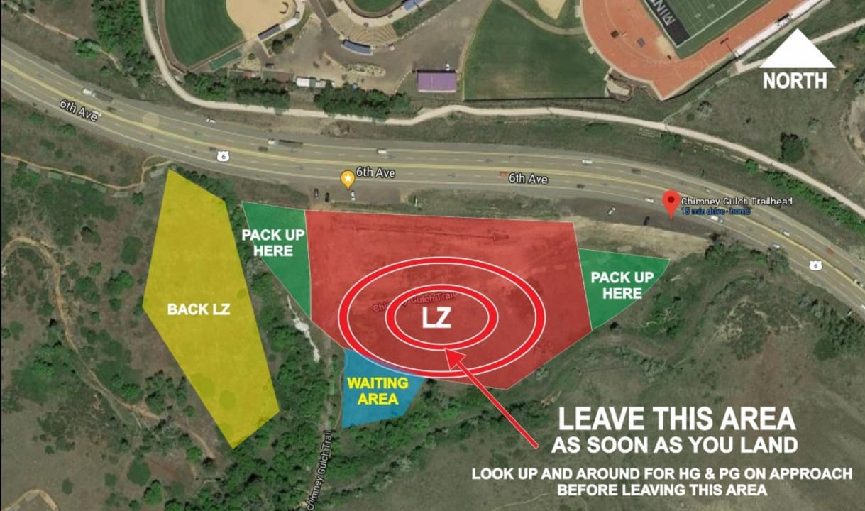
Primary Landing Zone
The primary LZ is about 400 yds by 200 yds and is surrounded by obstacles.
Pilots using the primary LZ must note:
- Highway 93 with power lines and a large metal highway sign adjacent to the LZ.
- Trees and homes on top of a mesa S of the LZ.
- The deep ditch separating the larger east and smaller west landing areas.
- The detention pond that is typically dry.
- Hang glider activity.
Pilots at Lookout typically use either a Figure-8 or Standard Aircraft Approach. For a Figure-8 approach, pilots typically approach from the W. Stay in your figure 8 pattern if you encounter lift. Wide S-turns will enable a gentle approach and avoid the need to make sharp turns close to the ground. For an Aircraft Approach, pilots typically begin by losing altitude over the hill to the SE of the LZ. When low enough, turn & fly over Hwy 93 to the NW. Extend or shorten your downwind leg as needed. The base leg is usually rather short, almost a 180 degree turn back into the LZ. If you are too high on final, finish the approach using the Figure 8 method.
The main LZ can be very poppy and turbulent midday. Wind direction has a considerable effect on landing conditions in the main LZ. Those are:
- E - Generally sinky due to down-sloping terrain. Come in high.
- N - Generally lifty due to up-sloping terrain. Come in low.
- S - Turbulent and sinky due to the terrain and houses S of the LZ. Come in high.
- W - Uncommon. Sometimes pilots will land facing W late in the evening in light catabatic conditions.
The LZ is challenging for hang gliders and they have limited landing options. After you land, look around for hang gliders on approach. Gather your equipment and move it to the pack up area. Do not pack up or loiter in the landing area. You will be a hazard to landing hang gliders. In mid-day conditions this LZ can be very thermic and is recommenced for advanced pilots only. There is a windsock a the top of the hill above the south east corner of the LZ. Hang glider pilots should check the grass height especially if landing with wheels.
CAUTION: Upon landing, check for pilots making approaches and then clear the LZ. Packing up in the LZ presents serious hazards for landing hang gliders.
South Landing Zone
The South LZ is used less commonly. It is a large gently sloping hill just S of the neighborhood below launch. It is a preferred landing option in S wind as the main LZ can be turbulent in this wind direction. It is also a useful LZ if you find yourself low and S of the main LZ. The down-sloping hill faces E. Landing facing E is not recommended as wings tend to glide at the same slope of the hill. Side-hill landing is recommended. It is recommended to walk this LZ before landing it so you can understand the challenges produced by the down-sloping aspect. Ask about this LZ during your site briefing.
Miniwings
- Glide Ratio
- 4:1
Site Considerations
- Parking at both launches is limited. Carpool when possible.
- Lookout is a popular site. Clear your turns. Follow standard thermal etiquette. Go with the established turn directions.
- Clear the landing zone after landing.
Weather Links
- Windy - Interactive Tool
- NREL: Winds/Weather at Eldorado Canyon (128 & 93) - Good indicator for coming West wind.
- NOAA: RUC forecast sounding for BJC (Broomfield)
- Lookout's Weather Station - Realtime Winds
If you are unfamiliar with these weather sites reach out to a local pilot.
Please use the documents and forms above in conjunction with an official sponsor. Sponsors are listed on the sponsorship sheet.
Ownership
- Launches: Jefferson County Open Space
- Primary LZ: Colorado School of Mines and the City of Golden
- South LZ: Colorado School of Mines