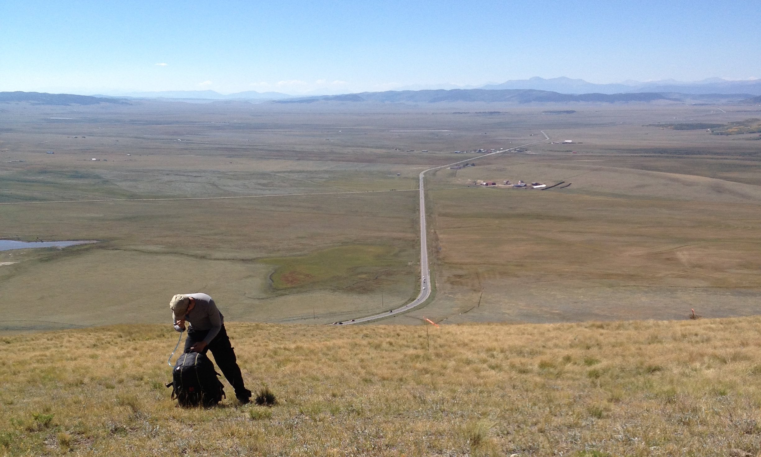
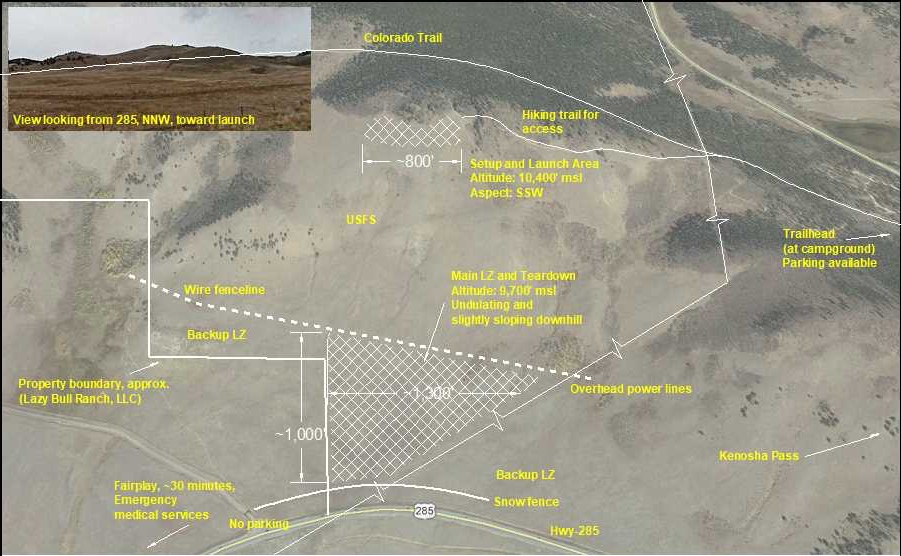
Kenosha Pass

Revision: Jan-2021
Located near Jefferson, CO, at the northeastern end of the south park basin, in Park County. Although this H2/P2 mountain site appears gentle and forgiving, conditions can change rapidly leading to dangerous flight conditions for both PG and HG (quickly becoming H3/P3+). The site sits at the top of the South Park basin and valley flow patterns (northerly/upslope conditions during daytime heating and southerly/downslope conditions) are the normal. Prior to flying this site, a thorough understanding of valley wind systems, wind compression, and thunderstorm hazards is highly recommended. Early morning conditions are mild. The site is good for HG, PG, and MW, and pilots learning mountain flying specifics. This is a high alititude site, solid and aggressive launch techniques required.

Launch

Launch elevation is about 10,400' msl, ideal launch aspects: SSW-S-SSE, moderate to clean slope, expansive area with many launch options, low grass and some shrub, some tape wind streamers may exist, pack all wind streamers out, launch access: hike from either Kenosha Pass via 4WD road/trail (see map) or from LZ near Hwy 285 (do not park on private property). GPS Coordinates: 39.414363N, -105.772963W
Kenosha Launch

Landing Zone

The main LZ is located on USFS property at an altitued of about 9,700' msl, undulating terrain with potholes, fast approach speeds in low wind conditions, low grass, cattle and bulls could be in the area -- if so, stay away/don't over-fly/land somewhere else/decide not to fly, pilots MUST understand where the USFS and private property lines are located- walk through with a local site guide/instructor is STRONGLY recommended, although the designated LZ is on USFS property, the landowner believes that their property extends farther than what is shown on maps (see map), tread lightly and don't walk through private property- to access Hwy 285 do not walk through the ranch's wooden fence/gate but directly east to the bend in the road, and remove all wind streamers upon departure. GPS Coordinates: 39.408237, -105.772905
Kenosha Launch

Site Considerations

Ideal Wind Range   Max Winds
HG 3 - 12 mph25 mph
PG 3 - 10 mph15 mph
MW 3 - 15 mph18 mph

Each pilot needs to individually determine his/her ideal flying conditions.

Daily Use Fee should be paid in the campground area, if camping or hiking through. Do NOT use gate in the landing area as it is on private property. Parking/pickup/dropoff is not allowed at Lazy Bull Ranch, LLC entrance, along Hwy 285, and the ranch’s access road. Without permission from CDOT and USFS, signage is not allowed. Cross over the fence only on the Forest Service side of the property. See site diagram for private property location.

Kenosha Pass Map

Miniwings

Close to highway, you can sledder or soar here. Check forecasts as winds can pick up quickly out of valley. Allow adequate separation from terrain, smallest recommended wing to make LZ: 12m.

Glide Ratio
3:1

Weather Notes

Great site when winds aloft are from the south and southwest. Wide open valley is located upwind. Thunderstorm development very serious concern. If storms are dropping out, especially upwind, do not fly. Due to valley flow (South Park system) winds can ramp up very quickly, leading to blowback. If blowback occurs, there are fields downwind. Kenosha Pass is a thermal site with ridge soaring potential. Miniwings often use the site due to the low glide ratio needed to reach the LZ. Flying potential in winter. XC opportunities. Beautiful in fall. Too early in the spring when snow is still present in the adjacent high-country, downsloping winds can result in very cross conditions. Do not fly alone.

Ideal Weather Conditions: S through SW synoptic weather pattern. Light winds aloft (through at least 18K, absence of jet stream). Low chance of thunderstorm development/OD.

Communications

Radio Frequency

158.400 MHz DCS 23 -- DCS Guide

New to the area?
  • Connect with local pilots on the forum RMHPA Forum
  • Ask a RMHPA member about the relevant Telegram groups.

Emergencies

Denver, Breckenridge, limited care in Fairplay. Emergency vehicles can access the LZ area from Hwy 285.

Documents