Copper Mountain Ski Area
Copper is an advanced P4 site that requires a ski pass and close cordination with the Ski Patrol. Summit County offers several other sites that are much less restrictive, and more accessable. Peak 6 is across the valley is flown frequently by pilots of all levels with mountain flying experience.
Access to launch in winter is available via the Super Bee lift, American Eagle + Excelerator lifts, and Storm King surface lift. When the mountain is open to the public during the summer season, the American Eagle lift operates from base to mid-mountain. From mid-mountain, there is a hike to the launch area. A special vehicle permit allows access on “A Road” from base to Patrol Headquarters (PHQ). Driving permits are only available to site coordinators.
No Tandems or instruction permitted.
In the winter, a season-pass or daily lift ticket is required for lift access. All pilots must have proper equipment to access the mountain and exit the mountain when conditions are not flyable. A site coordinator must give a site overview to all pilots. Pilots are required to sign liability and pilot form. Pilots must be added to the pilot list communicated with Ski Patrol in the winter and known as Bike Patrol in the summer. All pilots are required to check-in for flying activities.
Copper Mountain flying site is a high alpine site with about ~2500 feet of vertical from launch to landing zone. The launch site on Hallelujah Ridge (West Facing) requires a minimum of a P4 rating. (MINI WING & Hanggliders are not permitted). If there is interest hanglider access can be restored.
Requirements
- P4 Rating
- Must be a member of USHPA
- All pilots must be on the Pilot List with valid USHPA membership and signed liability and pilot waiver form.
- Pilots must check-in with Ski (Bike) Patrol to confirm ground clearance for flying activities.
- Site Briefing from a RMHPA Site Coordinator, Helmet, Radio (frequency 151.955 MHz) & Reserve Parachute.
- Paraglider with a minimum performance of 6:1 L/D
Weather
| Wind Directions | |
|---|---|
| Ideal | 270-300 ° West/Northwest |
| Marginal (Light Wind Only) | 230-360 ° Southwest/North |
| Ideal Wind Range | Max Winds |
|---|---|
| PG 0 - 5 mph | 10 mph |
| HG 3 - 12 mph | 10 mph |
Each pilot needs to individually determine his/her ideal flying conditions.
Communications
Radio Frequency
151.955 MHz
Telegram Groups
New to the area? Post a quick message about yourself so we know your'e not a spammer will get you access to the private Telegram groups.
RMHPA Telegram Groups
Clearance
There are natural obstacles at launch and landing zones. Pilots need to maintain a 500 feet clearance over terrain especially lifts, structures, buildings, vehicles, equipment and people. Winter Landing Zones are on the golf course, which provides long runway via golf course fairway. Summer landings have trees and imperfections on the ground exist. The Far East LZ has power lines on the east side along with trees around 75% of the open space.
Spectators are often present during flying activities. All spectators need to stay out of launch and closed areas. Pilots are permitted with the special site activity agreement to access ski resort closed area at launch. Winter landing zone includes cross-country skiing & snowcat paths, which may have people. Pilots need to prepare the flight plan before making a final approach in order to stay clear of all obstacles. Pilots should not land directly next to people.
Launch
Hallelujah Ridge PARAGLIDING SITE This is a P4 skill-level launch site
- Elevation
- 12,240 feet
- GPS Coordinates
- 39.4720 - 106.1572
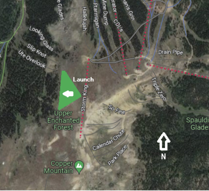
This west-facing launch is next to Storm King surface lift (T-bar) used in winter to access the launch area. Below the launch area is the Upper Enchanted Forest. In the winter, Ski Patrol must clear the Upper Enchanted Forest for avalanche danger. Once Upper Enchanted Forest is open to the public, Ski Patrol grants ground clearance to begin flying activities.
Several Streamers along Hallelujah Ridge show wind direction and speed. There are wind meters at all lift stations, so pilots can verify wind speed and direction when calling to Ski (Bike) Patrol to check-in for flying activity.
Weather
AWOS: 970-968-1715 (Location: Patrol Headquarter PHQ)
Access
For winter, a season-pass or daily lift ticket is required. All pilots must access the launch using approved equipment for the Ski Resort. (Skis with bindings or Snowboard) When weather is not suitable for flying activities, pilot need to leave the launch area. Ski Patrol clears the top of the mountain at 3pm. All pilots must clear the launch are before Ski Patrol makes the clearing sweep to close the area for all activities.
For summer, American Eagle lifts provides lift access when RMHPA has a special site agreement for flying activities. There is a hike from the mid-mountain Solitude Station to the top where launch is located. The hike generally takes between 30-45 minutes for pilots acclimated to high altitude conditions. Site coordinators can obtain a special permit and provide vehicle access from parking lot to Ski Patrol Headquarters (PHQ). There is a short hike to from Patrol Headquarters to launch.
Landing Zones
Winter Golf Course Hole #9
- Elevation
- 9,600 feet
- GPS Coordinates
- 39.4720 - 106.1572
Winter Golf Course Hole #8
- Elevation
- 9,600 feet
- GPS Coordinates
- 39.4720 - 106.149
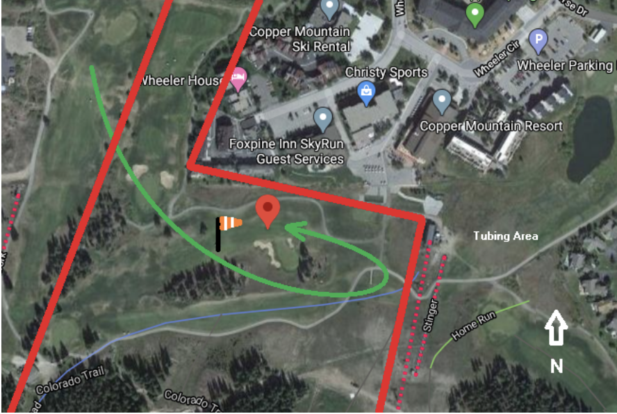
For Hole #8 in winter, pilots should descend using open area between Center and East Village over the golf course. The Woodward Barn and Fire Station are located to the north. Do not fly low over these buildings. When a pilot descends low enough, the final approach should fly from north to southwest. Do not land on Hole #2 west side or #3 on north side of West Tenmile Creek.
These areas have people. Ski School uses Hole #2 for instruction and there is sledding activities. All pilots need to stay clear. This fairway has many aspen trees, so there are obstacles. Do not land from south to north. The terrain elevation drops from south to north making landing difficult since there is a creek and water pump station on north side of creek.
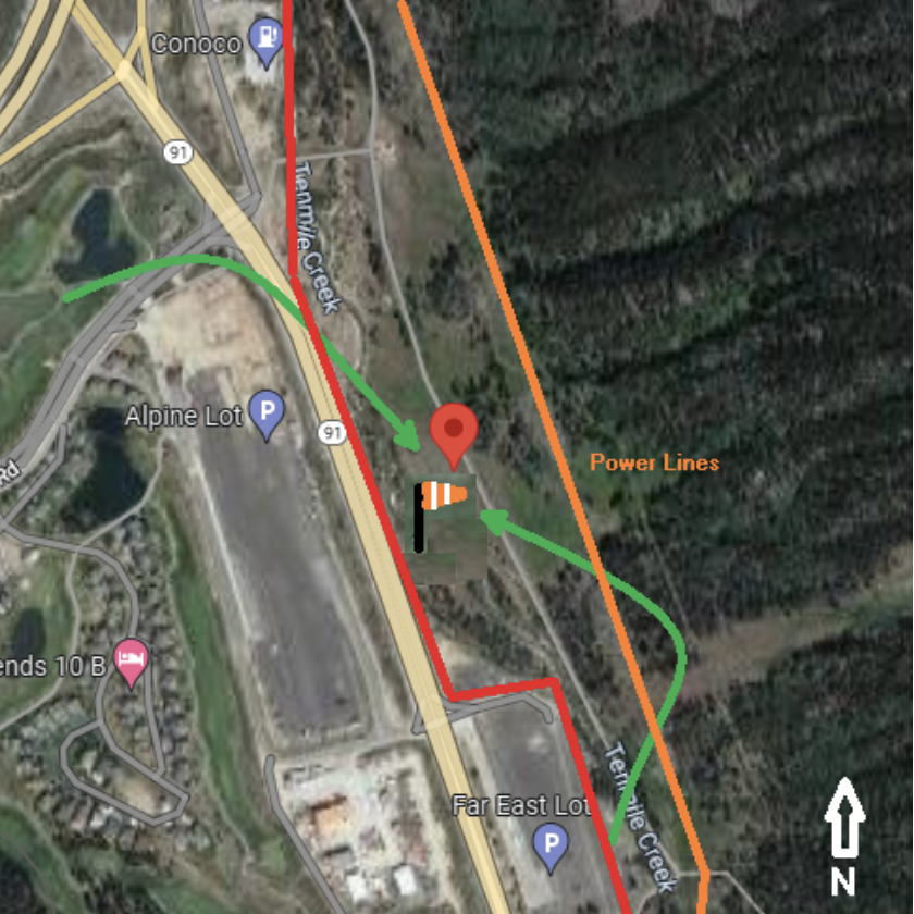
Winter Golf Course Hole #11
- Elevation
- 9,600 feet
- GPS Coordinates
- 39.5000 - 106.142
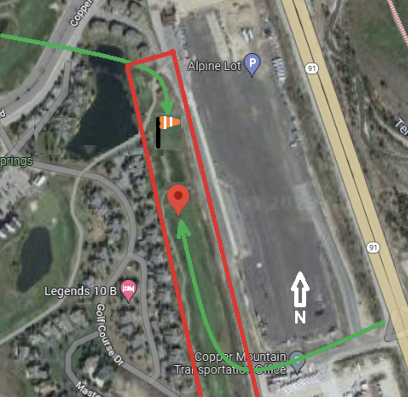
For Hole #11 in winter, pilots can land from either north or south direction. This landing zone is in the Vortex of mixing air flow of Vail Pass, Freemont Pass and Ten Mile Canyon. Wind direction can switch quickly in this landing zone. The prevailing wind is generally west, but wind can change from the north, east and south within minutes.
The landing zone is near townhomes, Alpine lot main transit station and the Copper Mountain Transportation office. There is a lot of pedestrian and vehicle activity near the landing zone. This is a very long golf course fairway, so pilots have plenty of time to prepare for the final approach.
Summer Far East Lot
- Elevation
- 9,600 feet
- GPS Coordinates
- 39.4970 - 106.136
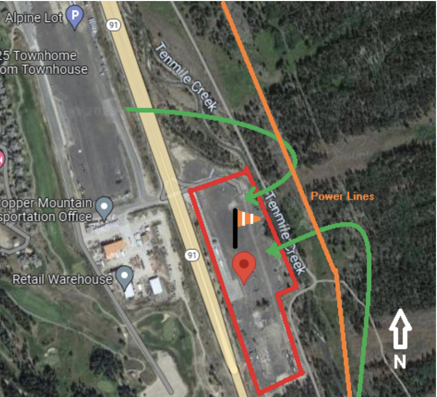
Far East Lot is part of the land lease between Copper Mountain Resort LLC and USFS. This landing zone requires a special agreement between RMHPA and Copper Mountain Resort LLC. Without an agreement this landing zone is not legal for pilots.
In the summer, the parking lots and valley release turbulent thermals. Launching from Peak 6 on Ten Mile Range once the parking lots have full sun is not recommended. Conditions can change quickly from stable soaring air to turbulent thermals. With prevailing west wind, there is a risk of getting blown over the Ten Mile Range. P2/P3 pilots should fly with local knowledgeable pilots and launch early from Ten Mile Range Peak 6.
Wind direction can change rapidly since the 3-way air flow merges at the parking lots. Air flow might start south from Freemont Pass but can quickly change west from Vail Pass. Wind speeds often increase quickly leaving little options along the Ten Mile Range. Always identify wind direction and speed before making a final approach. Do not land downwind.
Summer Bike Path
- Elevation
- 9,600 feet
- GPS Coordinates
- 39.5010 - 106.136
There is a landing zone are along the bike path of the Ten Mile Range. When RMPHA does not have a special agreement for the Far East Parking Lot, this landing zone is a viable option for pilots since the area is USFS.
This landing zone is difficult for P2 pilots. Pilots need to take different approaches depending on wind conditions. The area has rocks and uneven terrain. From the east, pilots are close to power lines. All pilots need to understand the risk and reward with hike & fly sites. Best to fly with experienced local pilots that are knowledgeable on the site & conditions.
Ownership
- United States Forest Service
- The Resort operation is owned and operated by Copper Mountain Resort LLC, under parent company, Powdr Corporation. Copper Mountain has a Metro District operated by the Village Company of Copper Association, Inc.